Fun with maps
-
@Arantor well, Brighton - say no more.
-
@pcooper said in Fun with maps:
but maybe I was too focused on looking at the US.
This is unpossible, since anything under 100% looking at the US is underfocus

-
@pcooper said in Fun with maps:
and the tilted-perspective look
It can actually be tilted with the right button mouse drag. The tilt by default does look a bit weird though—the maps in the books are not tilted, and in the movie it looks pretty much like camera flying over the map, so still indicating the map itself is not skewed, we are just looking at it obliquely.
-
-
@loopback0 They got the first one wrong:
-
@HardwareGeek covered by map 3, non?
-
@loopback0 More or less, but map 3 still classifies them as people.
-
-
@loopback0 said in Fun with maps:
Garages not shown
They're on a different layer (along with Termini).
-
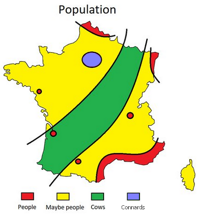
@loopback0 said in Fun with maps:
8 ways to divide France
Wait, haven't we done this before? Okay, guess not.
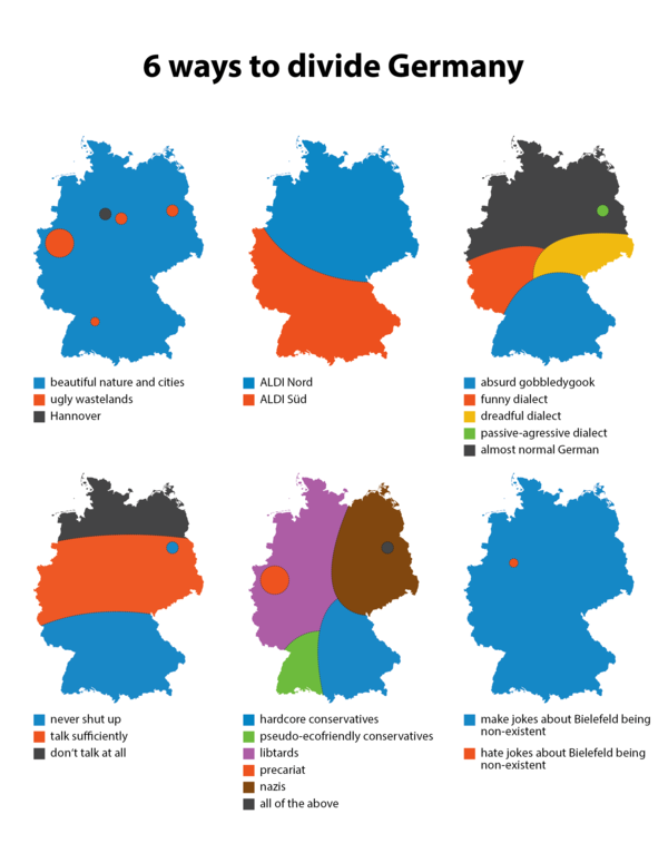
The only important one is #2. #5 is spot on, whereas #4 can't be right. It puts Cologne in "talk sufficiently", but they're clearly the ones belonging in "never shut up".
-
-
@topspin soon.
-
@topspin said in Fun with maps:
@loopback0 said in Fun with maps:
8 ways to divide France
Wait, haven't we done this before? Okay, guess not.
The only important one is #2. #5 is spot on, whereas #4 can't be right. It puts Cologne in "talk sufficiently", but they're clearly the ones belonging in "never shut up".
It seems to correspond well to religious denomination. The ones yappin' all the time are the Catholics; much like the famous phone sanitizers the Protestants just sent all their blabbermouths across the pond a while ago.
-
-

-
@loopback0 being cold and in the dark for most of the year is correlated with angry-sounding music.
-
@Benjamin-Hall said in Fun with maps:
@loopback0 being cold and in the dark for most of the year is correlated with angry-sounding music.
So the vodka keeps Russians warm enough they don't get into metal?

-
@izzion they’re too drunk too
singshout.
-

-
@boomzilla Oh dear, I just thought of the bottom 9 states...
-
-
@remi said in Fun with maps:
The answer is obviously Netherlands.
Good guess, but wrong:
Biscay, arisen from the depths.
-
@GOG You didn't read the link, did you?
-
@Bulb I read both; the What if? when it originally came out, even.
-

-
@loopback0
no hookers behind the station?
-
@Luhmann said in Fun with maps:
@loopback0
no hookers behind the station?Wdym they're just pictorialized - regular empty lots don't have breasts.
-
@BernieTheBernie said in Fun with maps:
@boomzilla Oh dear, I just thought of the bottom 9 states...
We try like hell not to do that, here.
-
-
@loopback0 said in Fun with maps:
Stockholm being the exception that confirms the rule? It lacks a river, a WW2 memorial avenue, tourist trap cathedral, some kind of tower and bridges people care about one way or another.
-
@Atazhaia But does it have the post-ww2 depressing housing blocks?
-
@PleegWat Of course! And we even have them in several other cities too thanks to Miljonprogrammet. (Mass construction of 1 million new houses in the 60s/70s.)
-
@loopback0 The American version will have an obligatory "Martin Luther King Jr Boulevard" in an area dominated by low-income housing.
-
-
@lolwhat said in Fun with maps:
Actually, that wasn't his full official name. It was actually "Slain Civil Rights Leader The Reverend Doctor Martin Luther King Junior Boulevard". Rolls off the tongue, don't it?
His friends called him "Slain" for short.
-
@Gurth said in Fun with maps:
@Gribnit said in Fun with maps:
empty lots
No such thing in European city centres.
They do exist! In the interval between one nice old thing being torn down and a concrete monstrosity being put up in its place.
-
@Atazhaia said in Fun with maps:
Stockholm being the exception that confirms the rule? It lacks a river
It has Mälaren and the Baltic instead.
-
@dkf said in Fun with maps:
@Gurth said in Fun with maps:
@Gribnit said in Fun with maps:
empty lots
No such thing in European city centres.
They do exist! In the interval between one nice old thing being torn down and a concrete monstrosity being put up in its place.
You have to be there at just the right time, though, probably only if the demolition finishes on a Friday and construction begins the following Monday morning.
-
-
@boomzilla Linked from lower down the thread:
-
Following links further:
-
@Gurth said in Fun with maps:
@dkf said in Fun with maps:
@Gurth said in Fun with maps:
@Gribnit said in Fun with maps:
empty lots
No such thing in European city centres.
They do exist! In the interval between one nice old thing being torn down and a concrete monstrosity being put up in its place.
You have to be there at just the right time, though, probably only if the demolition finishes on a Friday and construction begins the following Monday morning.
That would be a Chinese city
https://www.youtube.com/watch?v=N6f_sayw0mM
https://www.youtube.com/watch?v=vz_j_BEkVCQBerlin in particular is famous for taking years to exchange one concrete monstrosity for another.
-
@LaoC said in Fun with maps:
Berlin in particular is famous for taking years to exchange one concrete monstrosity for another.
Even longer if it is an airport.

-
@LaoC
I present the crown jewel of the Ohio Department of Transportation's concrete monstrosity exchanges: ODOT Improves ’Malfunction Junction’ in Dayton, Ohio : CEG

By Linda J. HutchinsonCEG CORRESPONDENTThe first two projects destined to improve “Malfunction Junction” in downtown Dayton, Ohio, are under way. Phase 1A and the Stanley Avenue project are the first two portions of a 10 to 12-year plan to modernize I-75 in western Ohio.
The first two projects destined to improve “Malfunction Junction” in downtown Dayton, Ohio, are under way. Phase 1A and the Stanley Avenue project are the first two portions of a 10 to 12-year plan to modernize I-75 in western Ohio.
(Spoiler: they did not complete the project in 12 years)
And this was the interstate junction in the middle of the sixth largest city in Ohio. I only assume that ODOT curls up in the corner and sucks their thumb whenever they have to contemplate interstate highway improvements in Columbus, Cleveland, or Cincinnati.
-
@izzion said in Fun with maps:
@LaoC
I present the crown jewel of the Ohio Department of Transportation's concrete monstrosity exchanges:
ODOT Improves ’Malfunction Junction’ in Dayton, Ohio : CEG
By Linda J. HutchinsonCEG CORRESPONDENTThe first two projects destined to improve “Malfunction Junction” in downtown Dayton, Ohio, are under way. Phase 1A and the Stanley Avenue project are the first two portions of a 10 to 12-year plan to modernize I-75 in western Ohio.
The first two projects destined to improve “Malfunction Junction” in downtown Dayton, Ohio, are under way. Phase 1A and the Stanley Avenue project are the first two portions of a 10 to 12-year plan to modernize I-75 in western Ohio.
(Spoiler: they did not complete the project in 12 years)
And this was the interstate junction in the middle of the sixth largest city in Ohio. I only assume that ODOT curls up in the corner and sucks their thumb whenever they have to contemplate interstate highway improvements in Columbus, Cleveland, or Cincinnati.
The right approach would have been to reroute I-75 so that it doesn't go through the middle of the city at all. And to close junctions outright because there's always a zone of increased congestion in the vicinity of off- and on-ramps and it's best to not mix them up.
But that's not how road construction theory rolls in the US from what I've seen.
-
@dkf said in Fun with maps:
The right approach would have been to abandon Ohio.
-
-
@dkf said in Fun with maps:
reroute I-75 so that it doesn't go through the middle of the city at all.
Dayton doesn't have a ring road, but it looks like you can take 75-675-70-75 to bypass the city center. It looks like it's probably close to 2x the distance of going through the city, so it might or might not save any time.
-
@HardwareGeek Doing it properly would involve rerouting from somewhere near Troy (north) to somewhere probably near Middletown (south). The added distance wouldn't be very great, but it would be a big project.
Contrast with I-70, which is far enough out to not need anything.
-
@dkf That seems pretty reasonable, although such a highway would not be named I-75; it would get a 3-digit number I-x75, where the x would be an even number because it's a bypass that intersects I-75 twice. (I-675 kinda fudges the rule, because it only intersects I-75 once, but it's still a bypass that intersects a main highway twice.)
Also, remember the highway system was designed 65 years ago, when there were only about 10% of the vehicles on the road that there are now. The point was to get from city to city (i.e., what is now the congested downtown, because the suburbs mostly didn't exist) as conveniently as possible. Nobody in 1956 would have imagined that traffic would increase 10x and that even 8+ lane highways could ever be congested to a standstill.