Fun with maps
-
-
@El_Heffe Reminds me of the talk going around like five years ago, when they wanted to split California into three parts, and even had names figured out for the parts.
So you could start in North California, travel south to California, continue in the same direction to South California, then on to Baja California, and finally to Baja California Sur.
-
@da-Doctah said in Fun with maps:
@El_Heffe Reminds me of the talk going around like five years ago, when they wanted to split California into three parts, and even had names figured out for the parts.
So you could start in North California, travel south to California, continue in the same direction to South California, then on to Baja California, and finally to Baja California Sur.
If implemented, the slacker actually assigning the names will screw up and swap California and South California - because they live in LA and want to stay in CA.
-
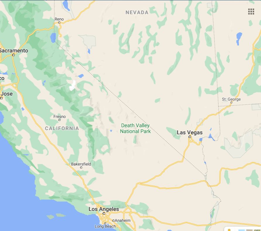
Los Angeles is on the Pacific Ocean. Reno, Nevada is 200 miles away from the ocean, and yet, Reno is farther west than Los Angeles
-
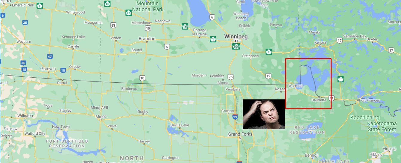
U.S. / Canada border
-
TL;DR:
Angle Township was designated as territory of the United States because negotiators of the initial Canada–U.S. border misunderstood the geography of the area.
Among other errors of early maps, the source of the Mississippi River wasn't where they thought it was.
-
-
@El_Heffe said in Fun with maps:
I am not sure I understand the issue... "Upper" means "up", not "north"
It's quite common for higher places to be south. Actually, this is the case of Germany, which is completely upside down on maps made with the modern convention (old maps had South up and North down, for this very reason).
-
@El_Heffe
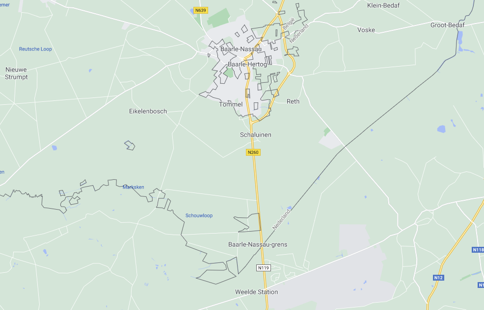
Pfff weak sauce compared to the Belgian/Dutch border ... no enclaves, parts that ended up isolated on a different river bank or parts that nobody wantedAnd let's not get started at the usage of the name 'Brabant'. Either a province in the Netherlands or a province in Belgium. No, they are not alongside the border like 'Limburg' because we cut out part of it and called it 'Antwerp'. We also didn't like our provinces being dual language so we split our Brabant up into three parts: Flemish, Walloon and Brussels. Because Brussels is a hellhole.
On a similar note: Luxembourg is both a Belgian province, a country and a city.
-
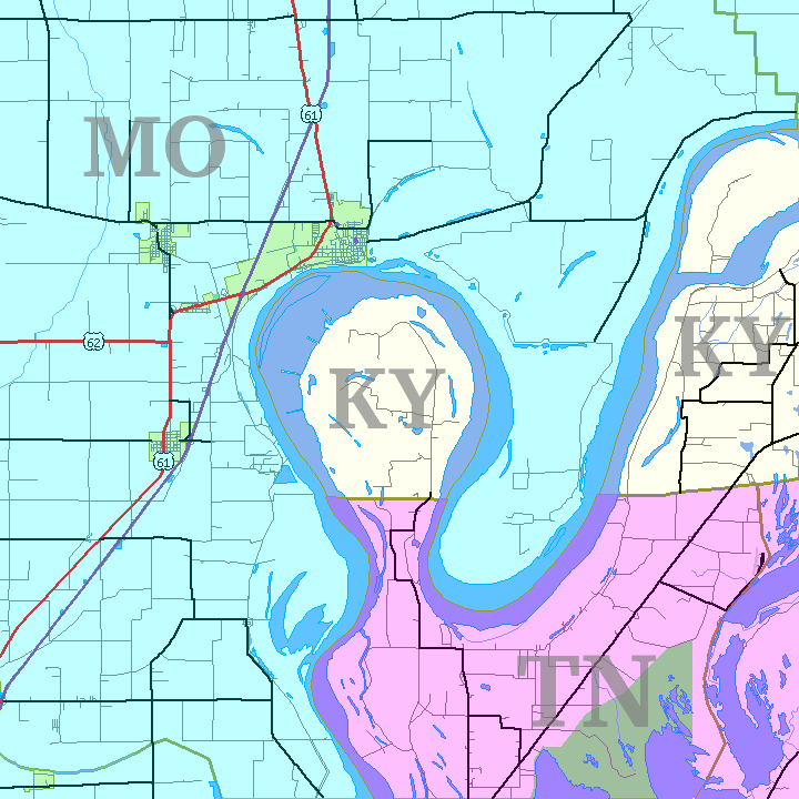
@HardwareGeek Usually when three states meet at a single point, there's only one such point for those three states. However, the states of Missouri, Kentucky and Tennessee meet at three distinct points in the vicinity of a feature called the Kentucky Bend, the New Madrid Bend, the Madrid Bend, the Bessie Bend, or Bubbleland.
-
@Luhmann said in Fun with maps:
Pfff weak sauce compared to the Belgian/Dutch border ... no enclaves, parts that ended up isolated on a different river bank or parts that nobody wanted
I was going to mention this horror.
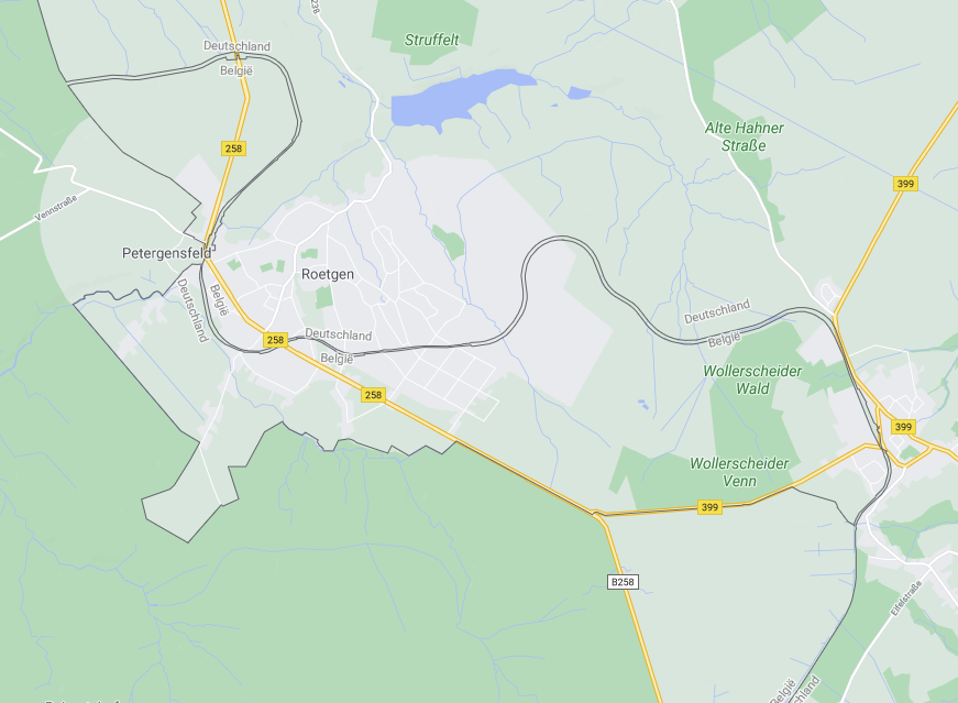
There's also the Vennbahn which causes this on the Belgian/German border.
-
@loopback0 You'd think that they'd have ceded that trackbed back to Germany once it stopped being used as a railway. I guess in these Schengen days it doesn't really matter, but that kind of border is a pain in the arse if you want to control it.
-
@loopback0
We like enclaves sooo much that during the 70ties when the language border (demarcation line between Dutch and French speaking) was drawn a few new ones where created but all in the spirit of waffle politics one side couldn't have one without the other side having one too. All forgetting the biggest enclave that was created. But that's ok because that place is a hellhole.
-

So instead of giving all of the island to Finland, the border goes straight across it. But the lighthouse belongs to Finland, but is on the swedish "half". So for the sake of equality, Sweden needs to get an equal share of the finnish side.
-
@Luhmann said in Fun with maps:
enclaves
Between Belgium and The Netherlands, even the enclaves have enclaves!
-
@Atazhaia said in Fun with maps:
So instead of giving all of the island to Finland, the border goes straight across it. But the lighthouse belongs to Finland, but is on the swedish "half". So for the sake of equality, Sweden needs to get an equal share of the finnish side.
and then I noticed the scale...
-
@Atazhaia IIRC, there's a fair amount of bad blood (not of the shooting kind, but the "longstanding historical grudge" kind) between those two nations. Seems like someone went "nope, not giving you anything extra here. No matter how petty or ridiculous, we'll get every square mm of land we're owed."
-
@loopback0 That's nuttier than the craziest bit of border in the UK, between England and Wales.

That's not a total enclave, but all roads from Pentrehayling to, well, anywhere at all, all go over the border.
-
@dkf
It even has a foggy bottom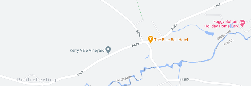
-
@dkf Also not an enclave but here's Saltney, which has the border running down the middle of the aptly named Boundary Lane.
The COVID-19 restrictions are different depending on which side of the street people live. The Wales (Flintshire) side is under "local lockdown" and the England (Cheshire) side is not.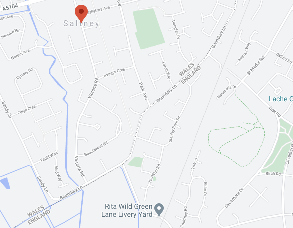
-
-
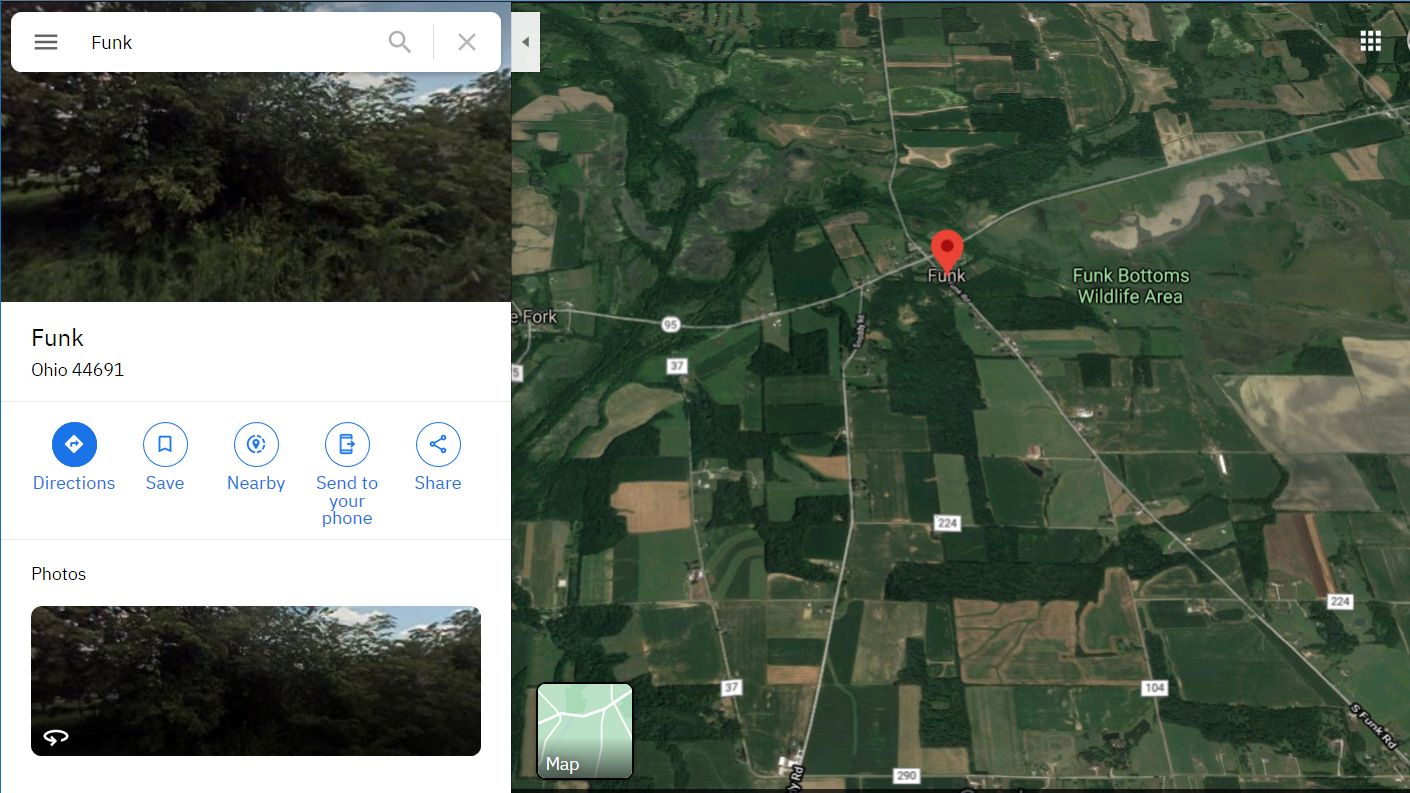
@El_Heffe
You have a Muddy Fork up your Funk Bottoms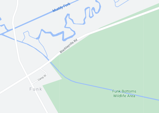
-
@loopback0 said in Fun with maps:
@dkf Also not an enclave but here's Saltney, which has the border running down the middle of the aptly named Boundary Lane.
The COVID-19 restrictions are different depending on which side of the street people live. The Wales (Flintshire) side is under "local lockdown" and the England (Cheshire) side is not.Well, now we finally know why the chicken crossed the road.
-
@Luhmann said in Fun with maps:
@El_Heffe
You have a Muddy Fork up your Funk BottomsThat's what SHE said.

-
-
-
@marczellm said in Fun with maps:
@Luhmann said in Fun with maps:
Brussels is a hellhole.
Why?
A combination. Half of all the bureaucrats of EU. And all the politicians of EU, half the time. And an extensive red lights district.
-
@acrow said in Fun with maps:
Half of all the bureaucrats of EU. And all the politicians of EU, half the time.
You forgot to mention that they speak French, despite the hinterland (including quite a lot of their 'burbs) speaking Flemish.
-
@marczellm
 ask
ask 
Making fun of Brussels is a bit of a Belgian thing even before the description.
The capital nobody wants. The place that only has beauty in its ugly architecture. The symbol of extreme paper pushing. Where chronic underfunding, feodal like local government, laissez-faire, socialist meddling and total incompetence are combined into one location that has more parliament and (inter-) governmental buildings then sensible.
-
@dkf said in Fun with maps:
@acrow said in Fun with maps:
Half of all the bureaucrats of EU. And all the politicians of EU, half the time.
You forgot to mention that they speak French, despite the hinterland (including quite a lot of their 'burbs) speaking Flemish.
I can't forget it if I don't know about it in the first place. I had enough reason to steer clear of the place already anyway; it's been on my Nope-list since EU got founded.
-
@acrow said in Fun with maps:
it's been on my Nope-list since EU got founded.
it should have been on it before ...
Look the place is named after a swamp. It is literally meaning is 'swamp house'.
-
@Luhmann said in Fun with maps:
@acrow said in Fun with maps:
it's been on my Nope-list since EU got founded.
it should have been on it before ...
Look the place is named after a swamp. It is literally meaning is 'swamp house'.And they bureaucracy still chose this particular place...
-
@acrow
It is all politics ... Germany didn't want it in a big country. France didn't want it in Germany. So they met halfway and took a dump.
-
@acrow said in Fun with maps:
[Brussels has] been on my Nope-list since EU got founded.
I've been a few times for work. It can be quite miserable in the winter.
-
@marczellm said in Fun with maps:
@Luhmann said in Fun with maps:
Brussels is a hellhole.
Why?
For a start, it's in B*****m.
-
@Luhmann said in Fun with maps:
Look the place is named after a swamp. It is literally meaning is 'swamp house'.
Do you mix that up with Kuala Lumpur?
Kuala = river estuary
Lumpur = mudWell, Hong Kong means "smelly harbor", Krung Thep (Thai name of Bangkok) means "city of angels", Singapore "palace of lions", ...
-
@acrow said in Fun with maps:
@marczellm said in Fun with maps:
@Luhmann said in Fun with maps:
Brussels is a hellhole.
Why?
A combination. Half of all the bureaucrats of EU. And all the politicians of EU, half the time. And an extensive red lights district.
So two downs and one up?
-
@acrow said in Fun with maps:
And an extensive red lights district.
Another thing where highly paid EU bureaucrats are pushing the prices up
-
@topspin said in Fun with maps:
@acrow said in Fun with maps:
@marczellm said in Fun with maps:
@Luhmann said in Fun with maps:
Brussels is a hellhole.
Why?
A combination. Half of all the bureaucrats of EU. And all the politicians of EU, half the time. And an extensive red lights district.
So two downs and one up?
For some people, I suppose. Unless you happen to live anywhere near it, in which case it's definitely all downsides.
 INB4: Yes, I'm aware that this also applies to amusement parks, airports, and similar...
-
@Luhmann I actually had to go and check when the Brussels Airport was built and why. Because sometimes those are built in places that are not suitable for other construction, like swamps and marshlands. But no, it was a WWII military airstrip.
-
@acrow said in Fun with maps:
But no, it was a WWII military airstrip.
That area (Zaventem) manages to be even more of a dump than Brussels itself. That's the place where I had a major meeting where we had to smuggle the networking through an absolutely brain-dead proxy (it only supported aggressively cached HTTP GET, not POST, not DNS, not anything else).
-
@dkf said in Fun with maps:
@acrow said in Fun with maps:
But no, it was a WWII military airstrip.
admittedly, this was in the middle of winter so dump-ness was maximised
I wouldn't be so sure.
Wikipedia says:
There is an urban legend that the site of the airport was chosen by the Germans after asking locals where to build it – the Belgians then pointed to this location as it was often foggy.
-
@acrow said in Fun with maps:
I wouldn't be so sure.
Can confirm. Not-quite-freezing-fog the whole time during that trip.
-
@Luhmann said in Fun with maps:
@El_Heffe
Pfff weak sauce compared to the Belgian/Dutch border ... no enclaves, parts that ended up isolated on a different river bank or parts that nobody wantedAnd let's not get started at the usage of the name 'Brabant'. Either a province in the Netherlands or a province in Belgium. No, they are not alongside the border like 'Limburg' because we cut out part of it and called it 'Antwerp'. We also didn't like our provinces being dual language so we split our Brabant up into three parts: Flemish, Walloon and Brussels. Because Brussels is a hellhole.
On a similar note: Luxembourg is both a Belgian province, a country and a city.See also: Prussia.
-
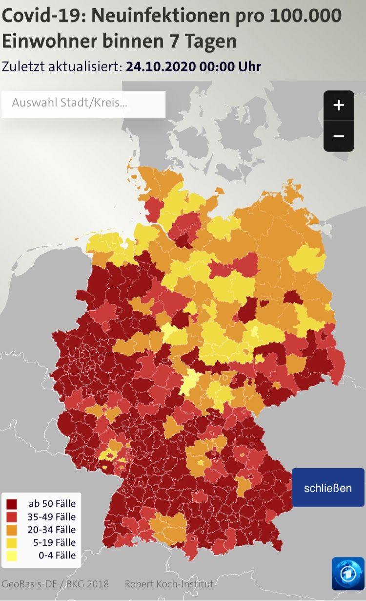
Ignore the colours, the legends, all that stuff. Rather, compare the shape of the Netherlands on this native map:
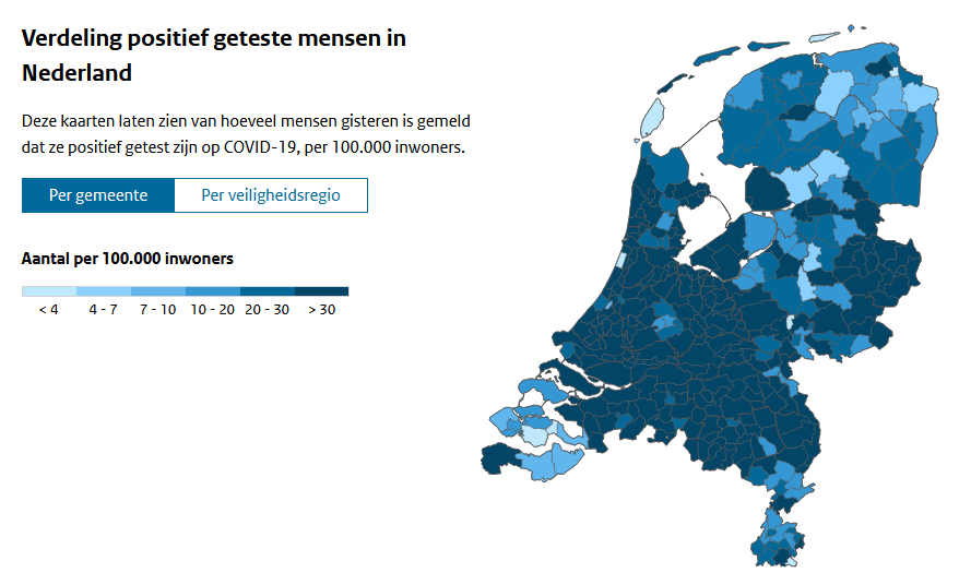
With this foreign one:
-
@Gurth Nothing obviously stands out. What did Ze Germans get wrong?
edit: oh, there's a bit near the North West that's different.
-
@Gurth Are you complaining about the IJselmeer which looks like land instead of sea on the german version?
-
This post is deleted!
-
@BernieTheBernie said in Fun with maps:
@Gurth Are you complaining about the IJselmeer which looks like land instead of sea on the german version?
And the dammed-off sea arms in the southwest, most of which are just outside the German map, but some parts aren’t. Non-Dutch maps usually take the edges of the land to be at the dams, probably on the basis that you generally don’t draw lakes inside a silhouette of a country. Dutch maps don't consider these areas lakes¹ and so they do appear on the map.
¹ Despite having names like IJsselmeer, Grevelingenmeer etc., where meer translates as “lake”.
-
@Gurth It would depend on the provider of the map data, given that the German site won't actually care too much about being accurate in the non-German parts of the map…
 Northwest Angle - Wikipedia


