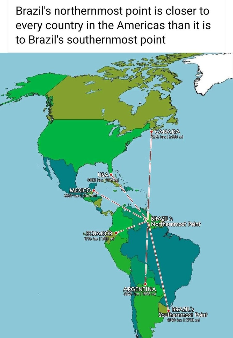
Fun with maps
-

 ///badger.badger.badger
This is the what3words address for a 3 metre square location near North Browning, Montana.
-
@loopback0 said in Fun with maps:
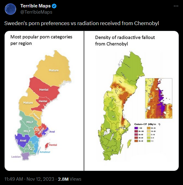
What am I supposed to take away from this? Weebs only grow where there is strong radiation? The sun must be covered in them!
-
 Watching this lady find out that Alaska isn't an island is the greatest smack down of the American education system I've seen in a while.

TikToker Savrienna Abrre had to move to Canada to learn U.S. geography.
Canada can have her.
-
@boomzilla But Alaska is always shown disconnected from the
Contiguous United States, just like Puetro Rico or Hawaii.
Well, return it to the Tsar of .
.
-
-
@loopback0 said in Fun with maps:
There was talk a few years ago into splitting the state in three parts the other direction. So from north to south, you'd have Northern California, California, Southern California, Baja California, and finally Baja California Sur.
-
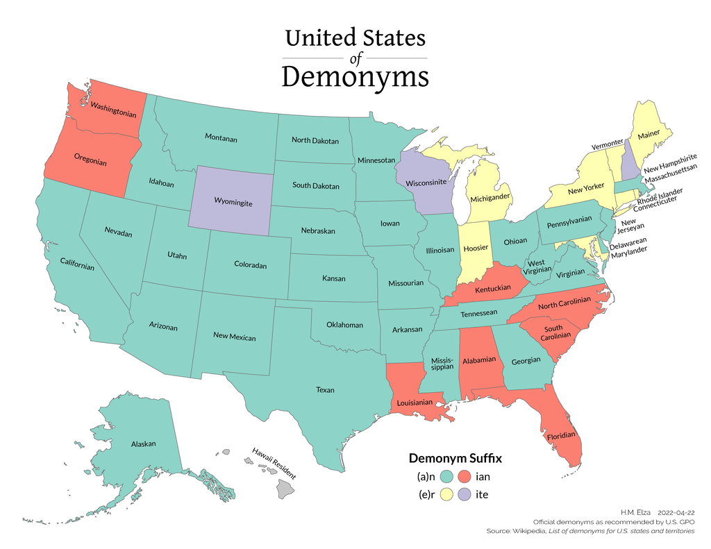
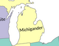
Hawaii Resident

https://en.wikipedia.org/wiki/List_of_demonyms_for_US_states_and_territories#
The Associated Press Stylebook restricts use of "Hawaiian" to people of Native Hawaiian descent.
I figured it would be something like that.
-
@Zecc They should go with "Hawaiish" and show those people who make demonyms a thing or two.
-
-
-
TFA says:
Michigoose (used specifically for female residents, as a play on "Michigander")
-
@dkf said in Fun with maps:
@Zecc They should go with "Hawaiish" and show those people who make demonyms a thing or two.
I'd use Hawaiiian.

-
At least there’s some rationale behind all of it. Unlike:—
-
@Zecc said in Fun with maps:
@dkf said in Fun with maps:
@Zecc They should go with "Hawaiish" and show those people who make demonyms a thing or two.
I'd use Hawaiiian.
Did you read the thing that you posted?
-
@dkf Yes. Hawaiiian.
But fine. It could be Hawaii-ian for clarity.
-
@Zecc Hawaii Ian, like Florida Man but with different shirts.
-
@dkf needs the Magnum PI tache as well.
-
@Gurth said in Fun with maps:
At least there’s some rationale behind all of it. Unlike:—
there is a rationale behind all of them.Not a simple rational, but there is one.

For Blois (like for many others) this is from the latin name Blesum.
-
@Zecc Hmm. "Massachusettsan" is a bit of a mouthful; I thought that the official term was "Bay Stater". Maybe that's specifically for a citizen and not just for a resident, though. (see also the Boston Globe's hard-hitting journalism answering this question, which includes the fun tidbit that "Masshole" is now officially in the Oxford English Dictionary.)
-
@pcooper said in Fun with maps:
@Zecc Hmm. "Massachusettsan" is a bit of a mouthful; I thought that the official term was "Bay Stater". Maybe that's specifically for a citizen and not just for a resident, though.
 : the correct term is "terrible"
-
@loopback0 said in Fun with maps:
: the correct term is "terrible"I think that's well covered by:
@pcooper said in Fun with maps:
"Masshole"
-
@remi said in Fun with maps:
there is a rationale behind all of them.Not a simple rational, but there is one.
I saw something on TV about that long ago, and the gist of it, IIRC, is that for demonyms that don’t resemble the placename at all, it’s that the demonym is for an older, often completely different, name that the place had.
-
-
@Gurth said in Fun with maps:
@remi said in Fun with maps:
there is a rationale behind all of them.Not a simple rational, but there is one.
I saw something on TV about that long ago, and the gist of it, IIRC, is that for demonyms that don’t resemble the placename at all, it’s that the demonym is for an older, often completely different, name that the place had.
A Haligonian, a Monegasque and a Burkinabe walk into a bar....
-
@da-Doctah said in Fun with maps:
splitting the state in three parts the other direction. So from north to south, you'd have Northern California, California, Southern California, Baja California, and finally Baja California Sur

-
@robo2 said in Fun with maps:
@da-Doctah said in Fun with maps:
splitting the state in three parts the other direction. So from north to south, you'd have Northern California, California, Southern California, Baja California, and finally Baja California Sur
 https://en.wikipedia.org/wiki/Six_Californias
Jefferson
North California
Silicon Valley
Central California
West California
South California
-
@robo2 said in Fun with maps:
@da-Doctah said in Fun with maps:
splitting the state in three parts the other direction. So from north to south, you'd have Northern California, California, Southern California, Baja California, and finally Baja California Sur
Three states by splitting the US state into 3 parts, plus the two existing Baja California states in Mexico.
-
@HardwareGeek thanks, makes more (not total) sense now.
-
diminish the state's reliability as a predominantly Democratic Party-supporting "blue state".
I'm not sure about that. 4 of the 6 new states would have had populous, blue cities. North California would have contained Sacramento, capital of the current shithole, as well as Marin County, wealthy suburb of San Francisco. Silicon Valley is obvious. West California would have contained Los Angeles. South California would have contained San Diego and Orange County. Only Jefferson and Central California would have been without major cities. The best they could have boasted would have been Redding and Bakersfield, respectively. If Bakersfield is the best you've got, you're in a sorry state, indeed!
-
@HardwareGeek Why did the proposer have such a hobby horse on this matter? He tried again apparently with a 3-way split idea, and that sort of thing gets expensive fast so he must've had some reason why he wanted to put so much money into something he must've known would be a very hard sell (especially the second time round).
-
@dkf said in Fun with maps:
Why did the proposer have such a hobby horse on this matter?
 Maybe he was trying to balance political power in California, but I'm not convinced.
-
-
@Gurth said in Fun with maps:
for demonyms that don’t resemble the placename at all, it’s that the demonym is for an older, often completely different, name that the place had.
At least for most of those mentioned in that article, it's mostly just your usual French word-mangling. Both the place name and the demonym are derived from the same original name, they just got gratuitously mangled in different ways. (AFAICT the demonyms usually seem to have stayed closer to the original, e. g. Saint Étienne vs Stéphanois)
-
@Zecc said in Fun with maps:
@HardwareGeek said in Fun with maps:
you're in a sorry state, indeed!
Was that a pun??
No, it was a play on words.
-
@ixvedeusi I'd say you're both right (
 ). It is "mostly just your usual French word-mangling" but at the same time in many cases this mangling is because "the demonym is for an older [...] name that the place had."
Demonyms that are (slightly) different from the current name often reflect how the name used to be written (or, equally if not more likely, spoken). TFA mentions the
^that hints to an oldsbut it's not hard to see several other common linguistic shifts (vowels at start of words or between two consonants that appear/disappear etc.).But there is a part of randomness in all that, even ignoring the obvious ones that are complete non-sense.
-
@PleegWat said in Fun with maps:
@Zecc said in Fun with maps:
@HardwareGeek said in Fun with maps:
you're in a sorry state, indeed!
Was that a pun??
No, it was a play on words.
Are you fishing for pendants?
Puns are a subset of plays on words; in particular when a word has multiple meanings.
-
-
@HardwareGeek You need to sort out getting Latin names for US states and cities so you can get really confusing demonyms too! Except for Ohio; that's fine as it is.
-
-
@Zerosquare said in Fun with maps:
Hint: this is @remi.
You can't fool me! I can see you're @Zerosquare.
Also the post I was replying to back then was from PleegWat.
-
-
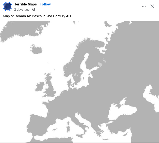
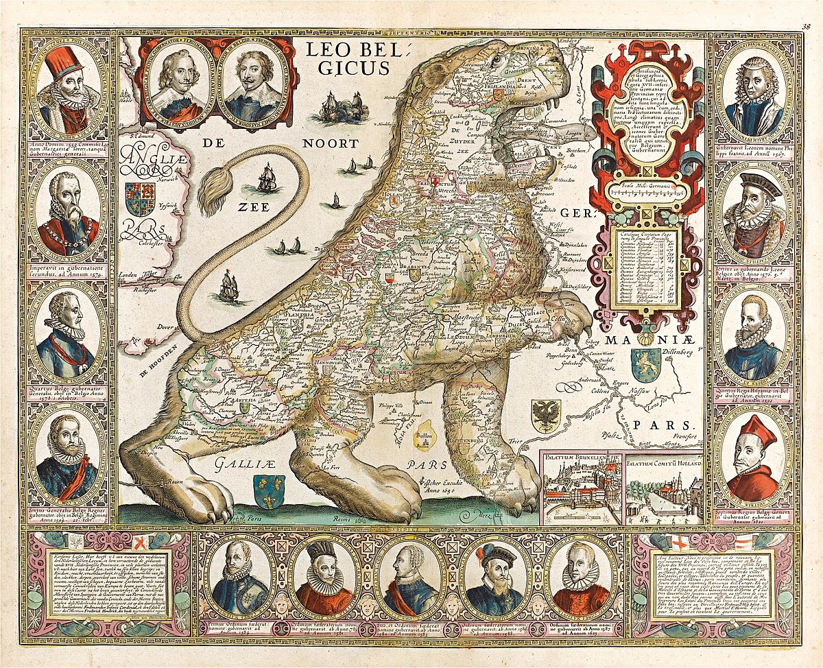
@boomzilla authoritative and accurate, best kind of map.
-
@Arantor said in Fun with maps:
@boomzilla authoritative and accurate, best kind of map.
I'm not so sure. The Dutch coast line is not period-accurate.
-
@PleegWat said in Fun with maps:
@Arantor said in Fun with maps:
@boomzilla authoritative and accurate, best kind of map.
I'm not so sure. The Dutch coast line is not period-accurate.
How do you know that Rome didn't just stuff barbarians in the dykes?

-
@PleegWat said in Fun with maps:
@Arantor said in Fun with maps:
@boomzilla authoritative and accurate, best kind of map.
I'm not so sure. The Dutch coast line is not period-accurate.
Well of Hollandia was real I might be worried.
-
@PleegWat said in Fun with maps:
@Arantor said in Fun with maps:
@boomzilla authoritative and accurate, best kind of map.
I'm not so sure. The Dutch coast line is not period-accurate.
That's primarily for cross-referencing to modern day locations. You know that people would get very confused if period-accurate geo-geometry were used, they'd be asking where half of the Netherlands is.
The specific cited data - locations of Roman air bases in 2nd Century AD Europe - is fully accurate and precisely geolocated.
-
@Arantor
 A lot of territory which was reclaimed starting the 17th century was not lost until well after the Roman era, with the All Saint's Flood in 1170 and the Saint Nicolas' Flood in 1196 being notable.The latter article has a cross-reference of floods in The Netherlands at the bottom, but it doesn't look like the ancient ones have English versions.
-
@PleegWat my bad, people looking at a period accurate map would be confused where part of the Netherlands went.
But it still shows complete, accurate information otherwise - and ties it to modern geography for current users' points of reference. I'd call that thoughtful personally.
-
-


 Blèsoise – a demonym | Aussie in France
 Netherlands in the Roman era - Wikipedia
 Sint-Nicolaasvloed - Wikipedia