Fun with maps
-
@error_bot !xkcd 977
-
-
@Bulb said in Fun with maps:
@dkf No, they don't. The projection must be angle-preserving to do that. If it isn't, then if you zoom in far from the centre, it is all skewed. I don't think any other projection preserves angles globally.
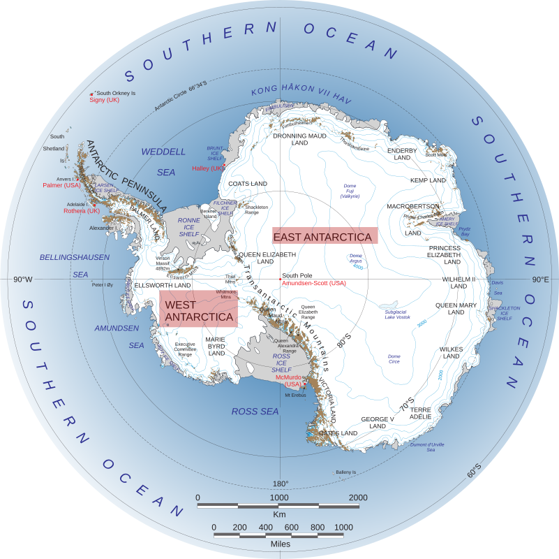
Well, I suppose Franz Josef Land has somewhat correct shape (cba to check, this particular map looks quite inaccurate anyway), but on the other way it is about the same size as India and bigger than Germany.
-
@Kamil-Podlesak When you zoom on Franz Josef Land, you don't see how completely out-of-scale Germany is at the same zoom level. You just see the scale ruler, which matches locally, and all the junctions you cross have the same shape as in reality, which is exactly what you want.
If you have vector map, you can use orthographic projection centred on the centre of the view like the Google maps do now. But if you have rasters, you end up with Mercator. The scale skewing is horrible, but most people need the large scale view only to pick the region they are interested in and there the different scale for different region does not matter, because you only see specific region, and angles are not distorted.
-
@Carnage said in Fun with maps:
@Bulb said in Fun with maps:
@dkf No, they don't. The projection must be angle-preserving to do that. If it isn't, then if you zoom in far from the centre, it is all skewed. I don't think any other projection preserves angles globally.
If you make a star shape with the cuts along the latitude lines and flatten with either pole in the center, you'd get a fairly decent version. You'd just have to ignore the holes between the arms.
Authagraph is a pretty good projection, and it should be used more.You are a lying liar who is lying.
-
Now that Fucking is no more:
The name of this German village means "Son-in-law's Buttocks" and as you can see on the administrative border about a kilometer west of it it's part of the municipality of Linsengericht, or "Lentil Meal".
There's also the hamlet of Cat Brain and at least two places are named Hate Hole.
-
-
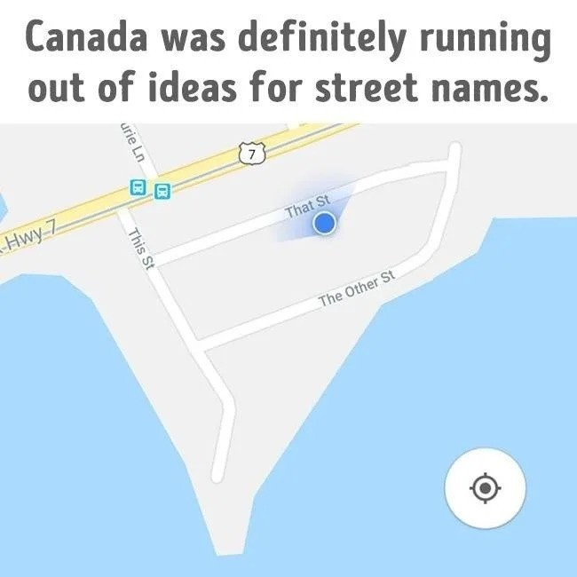
// FIXME: replace temporary street names before release
-
@LaoC Don't forget Colourful Cow.
And I once was able to get out of school one day early before the holidays because I told my teacher that we were going to Brazil which is next to California.
And then, of course, to rival the Canadian creativity, there a village called Place
Last but not least: Morons' Home
-
@Rhywden said in Fun with maps:
@LaoC Don't forget Colourful Cow.
And I once was able to get out of school one day early before the holidays because I told my teacher that we were going to Brazil which is next to California.
And then, of course, to rival the Canadian creativity, there a village called Place
Last but not least: Morons' Home
Moron's Home is probably just a town where there was a moron home.
-
@Gribnit said in Fun with maps:
@Rhywden said in Fun with maps:
Last but not least: Morons' Home
Moron's Home is probably just a town where there was a moron home.
Now that's one original theory!!!11
They used to have Stupidville that was just the founder's name that got changed quite a bit over the centuries, but they renamed it in the 70s just like Fucking. Stupider still exists though.
There are also the villages of Ouch, Vomiting, Lederhose, No Joke and Fuckingmill.
-
@LaoC
Not a village, but here's Lake Unknown.
-
@Watson
let me know if you find Lake NaN or NULL
-
@Luhmann said in Fun with maps:
@Watson
let me know if you find Lake NaN or NULL
-
@dcon
Ofcourse ...
But google was so kind to point me to a different not-null null lake ...
https://www.google.com/maps/place/Null+Lake/@50.5353725,-90.0535273,14z/data=!4m14!1m7!3m6!1s0x529fd7a718e019dd:0x5fbb49e8539ab1cf!2sNull+Lake!3b1!8m2!3d50.5413711!4d-90.0460484!3m5!1s0x529fd7a718e019dd:0x5fbb49e8539ab1cf!8m2!3d50.5413711!4d-90.0460484!15sCgludWxsIGxha2WSAQRsYWtl
-
@Luhmann My initial search did find a couple. I just picked one...
Finding Lake NaN will be hard - because it finds Lake Nan.
-
@dcon well, NaN != Nan
-
-
-
-
@Zecc .
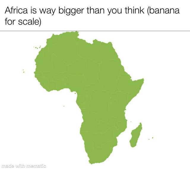
I bet there are a crazy lot of banana's for scale in this picture
I
-
@Luhmann no. They grow in their own shade and are not visible from space.
-
@Gribnit How do you confirm that all the bananas cannot be seen from space?
-
@Gribnit said in Fun with maps:
@Luhmann no. They grow in their own shade and are not visible from space.
@Luhmann posted an excellent photo. The country borders and the south pole's Google tag are all particularly well visible.
-
@Zecc
As is the snow covered region in North Congo
-
@dkf said in Fun with maps:
@Gribnit How do you confirm that all the bananas cannot be seen from space?
By looking
-
@Luhmann said in Fun with maps:
As is the snow covered region in North Congo
At least it isn't Colombia.
-
@dkf Different kind of white powder.
-
-
@loopback0
E_TRACTOR_NOT_FOUND
-
@Luhmann said in Fun with maps:
@Zecc .
I bet there are a crazy lot of banana's for scale in this picture
IYes, rather towards the top. In
 .
.
-
@BernieTheBernie
the country is is bananas ...
-
@Luhmann said in Fun with maps:
the country is is bananas ...
Chapeau Banana - 25cl - Buy beer online
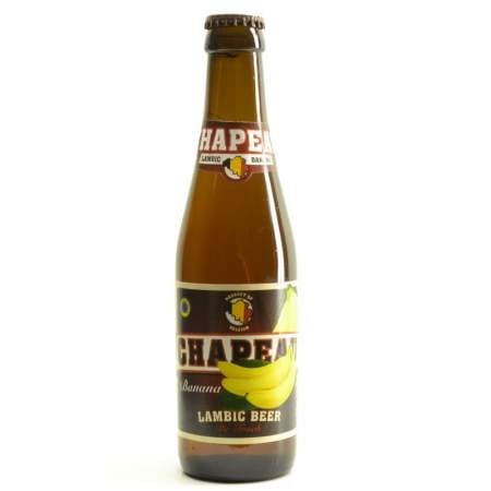
Chapeau Banana - 25cl. Buy your Chapeau beer and matching beer glass in this online shop. This Belgian beer is blond, fruity and brewed by De Troch brewery. ...
-
 could not be reached for comment.
-
-
-
@dkf
To be honest ... there is also this one

-
-
@HardwareGeek said in Fun with maps:
@dkf said in Fun with maps:
blond, fruity

“Is that a banana in your pocket or are you just pleased to be having a Belgian beer?”
-
@dkf said in Fun with maps:
@HardwareGeek said in Fun with maps:
@dkf said in Fun with maps:
blond, fruity
“Is that a banana in your pocket or are you just pleased to be having a Belgian beer?”
There's no call for that kind of language. In fact, it's conspicuously unmotivated.

-
@dkf said in Fun with maps:
@HardwareGeek said in Fun with maps:
@dkf said in Fun with maps:
blond, fruity
“Is that a banana in your pocket or are you just pleased to be having a Belgian beer?”
Actually, it's another Belgian beer. Would you like one?
-
-
@Zecc Not pictured: Springfield, Springfield, Springfield, Springfield, Springfield, Springfield, Springfield, Springfield, and Springfield. Not to mention Springfield, Springfield and any other Springfields I may have missed
-
@Zecc Pity the people who are not only stuck living in Detroit, but that Detroit is in the middle of Kansas.
-
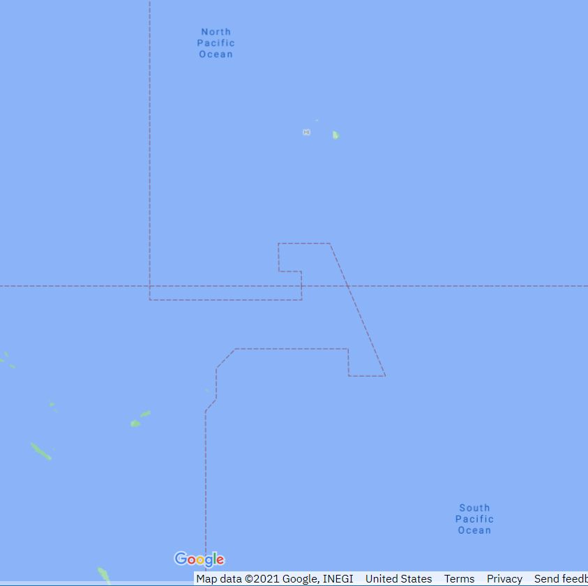
The International Date Line. I'm sure politics had absolutely nothing to do with this.
-
This post is deleted!
-
@El_Heffe said in Fun with maps:
The International Date Line. I'm sure politics had absolutely nothing to do with this.
It doesn't. That's the rocker latch to keep the days from cycling out of control.
-
@El_Heffe said in Fun with maps:
The International Date Line. I'm sure politics had absolutely nothing to do with this.
You’re right, it didn’t. Tourism had everything to do with it.
As a British colony, the now-Republic of Kiribati was centered in the Gilbert Islands, just west of the IDL of the time. Upon independence in 1979, it acquired the claim to the Phoenix and Line Islands, east of the IDL, from the United States. As a result, the country straddled the IDL. Government and commercial concerns on opposite sides of the line could only conduct routine business by radio or telephone on the four days of the week which were weekdays on both sides. To eliminate this anomaly, Kiribati introduced a change of date for its eastern half by removing Saturday, 31 December 1994 from its calendar. After the change, the IDL in effect moved eastwards to go around the entire country. Strictly legal, the 1917 nautical IDL convention is still valid. When the land time zone says it's Monday, these islands would form enclaves of Monday in an ocean which has Sunday. Maps are usually not drawn this way.[24]
As a consequence of the 1994 change, Kiribati's easternmost territory, the Line Islands, including the inhabited island of Kiritimati (Christmas Island), started the year 2000 before any other country, a feature the Kiribati government capitalized upon as a potential tourist draw.
From https://en.wikipedia.org/wiki/International_Date_Line#Eastern_Kiribati_(1994)
-
@Gurth said in Fun with maps:
@El_Heffe said in Fun with maps:
The International Date Line. I'm sure politics had absolutely nothing to do with this.
You’re right, it didn’t. Tourism had everything to do with it.
As a British colony, the now-Republic of Kiribati was centered in the Gilbert Islands, just west of the IDL of the time. Upon independence in 1979, it acquired the claim to the Phoenix and Line Islands, east of the IDL, from the United States. As a result, the country straddled the IDL. Government and commercial concerns on opposite sides of the line could only conduct routine business by radio or telephone on the four days of the week which were weekdays on both sides. To eliminate this anomaly, Kiribati introduced a change of date for its eastern half by removing Saturday, 31 December 1994 from its calendar. After the change, the IDL in effect moved eastwards to go around the entire country. Strictly legal, the 1917 nautical IDL convention is still valid. When the land time zone says it's Monday, these islands would form enclaves of Monday in an ocean which has Sunday. Maps are usually not drawn this way.[24]
As a consequence of the 1994 change, Kiribati's easternmost territory, the Line Islands, including the inhabited island of Kiritimati (Christmas Island), started the year 2000 before any other country, a feature the Kiribati government capitalized upon as a potential tourist draw.
From https://en.wikipedia.org/wiki/International_Date_Line#Eastern_Kiribati_(1994)
People on the last
onever really got on with the folks ong, either.
-
@hungrier said in Fun with maps:
@Zecc Not pictured: Springfield, Springfield, Springfield, Springfield, Springfield, Springfield, Springfield, Springfield, and Springfield. Not to mention Springfield, Springfield and any other Springfields I may have missed
I once went off on a tear looking for US cities with the same name as cities elsewhere (someone said he was leaving for a new job in Alexandria, and had asked if he meant Egypt or Virginia). The goal was to find the largest matching pair, where "largest" was defined by the less populous of the two cities in the pair (wouldn't do to find a barren crossroads somewhere in Africa called "Chicago", or a lnear-abandoned mining camp called "Shanghai" in Montana).
The wining pair, for those now wondering, was San Jose.