Fun with maps
-
@HardwareGeek said in Fun with maps:
The point was to land aircraft 2/5 of anywhere, and put tanks and artillery on the rest of it
Pretty sure that's well-known, it was a decent superweapon for its time.
-
@HardwareGeek said in Fun with maps:
Nobody in 1956 would have imagined that traffic would increase 10x and that even 8+ lane highways could ever be congested to a standstill.
Not for another six years, it seems, no:
 Fundamental law of road congestion: Evidence from U.S. cities - The Journalist's Resource

2011 study from the University of Toronto and London School of Economics on the relationship between infrastructure and automotive traffic levels.
Also:
-
@HardwareGeek said in Fun with maps:
even 8+ lane highways could ever be congested to a standstill.
I'm no urban planner but I don't think more than 3 lanes has ever been a good idea for any highway. Vast majority of drivers want to exit at a nearby exit, and the exit is almost always at the far right edge of the road (sometimes far left edge of the road). Therefore, your route choices are:
- enter highway, stay in the rightmost lane (lane #1), exit highway
- enter highway, temporarily block lane #1 when switching lanes, drive on lane #2, temporarily block lane #2 when you go back to #1, exit highway
- enter highway, temporarily block lanes #1 and #2 when switching lanes, drive on lane #3, temporarily block lanes #3 and #2 when you go back to #1, exit highway
- enter highway, temporarily block lanes #1, #2 and #3 when switching lanes, drive on lane #4, temporarily block lanes #4, #3 and #2 when you go back to #1, exit highway
- and so on.
Multiply by all the cars entering and exiting the highway during the day. All that blocking adds up - and the more lanes you cross, the more you block the traffic.
Instead of adding more lanes, they should've built less exits. It would make traffic smoother and save money.
-
@HardwareGeek said in Fun with maps:
Nobody in 1956 would have imagined that traffic would increase 10x and that even 8+ lane highways could ever be congested to a standstill.
Only 8 lanes?? What a ridiculous lack of foresight.
Real edit: I will repost this until it stops being funny
-
@HardwareGeek said in Fun with maps:
@dkf That seems pretty reasonable, although such a highway would not be named I-75; it would get a 3-digit number I-x75, where the x would be an even number because it's a bypass that intersects I-75 twice. (I-675 kinda fudges the rule, because it only intersects I-75 once, but it's still a bypass that intersects a main highway twice.)
The particular routes of highways are laws of God? Or set by Federal legislation? I really don't believe that. You'd build the bypass de novo mostly on cheaper non-urban/non-suburban land, then declare that the bypass is the main highway and that the former highway is the loop/spur. Through traffic will use the new route, and local traffic won't (except for some dimwits, and we can laugh at them). The important part of this will be making sure that the new highway doesn't have so many junctions.
If problems are caused by historical decisions being outpaced by reality, you get on and fix things including looking at whether decisions should be reversed.
-
@dkf Especially if, like in much of the USA, you have land to spare that you could do this on.
-
@Gurth said in Fun with maps:
@dkf Especially if, like in much of the USA, you have land to spare that you could do this on.
That land has rights, you know.
Also, a lot of it is not near where a new road is needed. Land-price pressure follows traffic-pressure - this is done by acoustically perfect gnomes.
-
@Gribnit Of course. But land can be purchased, after evicting the gnomes, so that a road can be built on it in a location that works best for traffic flow, livability of the area, etc. This would free up parts of the city, where the road used to be, to make the place better as a city rather than as a place to park cars one behind the other.
-
-
@dkf said in Fun with maps:
@izzion said in Fun with maps:
@LaoC
I present the crown jewel of the Ohio Department of Transportation's concrete monstrosity exchanges: ODOT Improves ’Malfunction Junction’ in Dayton, Ohio : CEG

By Linda J. HutchinsonCEG CORRESPONDENTThe first two projects destined to improve “Malfunction Junction” in downtown Dayton, Ohio, are under way. Phase 1A and the Stanley Avenue project are the first two portions of a 10 to 12-year plan to modernize I-75 in western Ohio.
The first two projects destined to improve “Malfunction Junction” in downtown Dayton, Ohio, are under way. Phase 1A and the Stanley Avenue project are the first two portions of a 10 to 12-year plan to modernize I-75 in western Ohio.
(Spoiler: they did not complete the project in 12 years)
And this was the interstate junction in the middle of the sixth largest city in Ohio. I only assume that ODOT curls up in the corner and sucks their thumb whenever they have to contemplate interstate highway improvements in Columbus, Cleveland, or Cincinnati.
The right approach would have been to reroute I-75 so that it doesn't go through the middle of the city at all. And to close junctions outright because there's always a zone of increased congestion in the vicinity of off- and on-ramps and it's best to not mix them up.
But that's not how road construction theory rolls in the US from what I've seen.
I don't know much about the history but I'll bet most of that urban area (and there's really not that much) built up after the Interstates showed up.
-
@Gurth said in Fun with maps:
But land can be purchased, after evicting the gnomes, so that a road can be built on it in a location that works best for traffic flow, livability of the area, etc.
This requires a series of consecutive and rational decisions and actions of a length so moderate, that it will never occur.
-
@boomzilla said in Fun with maps:
@dkf said in Fun with maps:
@izzion said in Fun with maps:
@LaoC
I present the crown jewel of the Ohio Department of Transportation's concrete monstrosity exchanges:
ODOT Improves ’Malfunction Junction’ in Dayton, Ohio : CEG
By Linda J. HutchinsonCEG CORRESPONDENTThe first two projects destined to improve “Malfunction Junction” in downtown Dayton, Ohio, are under way. Phase 1A and the Stanley Avenue project are the first two portions of a 10 to 12-year plan to modernize I-75 in western Ohio.
The first two projects destined to improve “Malfunction Junction” in downtown Dayton, Ohio, are under way. Phase 1A and the Stanley Avenue project are the first two portions of a 10 to 12-year plan to modernize I-75 in western Ohio.
(Spoiler: they did not complete the project in 12 years)
And this was the interstate junction in the middle of the sixth largest city in Ohio. I only assume that ODOT curls up in the corner and sucks their thumb whenever they have to contemplate interstate highway improvements in Columbus, Cleveland, or Cincinnati.
The right approach would have been to reroute I-75 so that it doesn't go through the middle of the city at all. And to close junctions outright because there's always a zone of increased congestion in the vicinity of off- and on-ramps and it's best to not mix them up.
But that's not how road construction theory rolls in the US from what I've seen.
I don't know much about the history but I'll bet most of that urban area (and there's really not that much) built up after the Interstates showed up.
Fascinating. And how much will you be betting?
-
@Gribnit said in Fun with maps:
@boomzilla said in Fun with maps:
@dkf said in Fun with maps:
@izzion said in Fun with maps:
@LaoC
I present the crown jewel of the Ohio Department of Transportation's concrete monstrosity exchanges:
ODOT Improves ’Malfunction Junction’ in Dayton, Ohio : CEG
By Linda J. HutchinsonCEG CORRESPONDENTThe first two projects destined to improve “Malfunction Junction” in downtown Dayton, Ohio, are under way. Phase 1A and the Stanley Avenue project are the first two portions of a 10 to 12-year plan to modernize I-75 in western Ohio.
The first two projects destined to improve “Malfunction Junction” in downtown Dayton, Ohio, are under way. Phase 1A and the Stanley Avenue project are the first two portions of a 10 to 12-year plan to modernize I-75 in western Ohio.
(Spoiler: they did not complete the project in 12 years)
And this was the interstate junction in the middle of the sixth largest city in Ohio. I only assume that ODOT curls up in the corner and sucks their thumb whenever they have to contemplate interstate highway improvements in Columbus, Cleveland, or Cincinnati.
The right approach would have been to reroute I-75 so that it doesn't go through the middle of the city at all. And to close junctions outright because there's always a zone of increased congestion in the vicinity of off- and on-ramps and it's best to not mix them up.
But that's not how road construction theory rolls in the US from what I've seen.
I don't know much about the history but I'll bet most of that urban area (and there's really not that much) built up after the Interstates showed up.
Fascinating. And how much will you be betting?
A few InternetPointz.
-
@boomzilla said in Fun with maps:
@Gribnit said in Fun with maps:
@boomzilla said in Fun with maps:
@dkf said in Fun with maps:
@izzion said in Fun with maps:
@LaoC
I present the crown jewel of the Ohio Department of Transportation's concrete monstrosity exchanges:
ODOT Improves ’Malfunction Junction’ in Dayton, Ohio : CEG
By Linda J. HutchinsonCEG CORRESPONDENTThe first two projects destined to improve “Malfunction Junction” in downtown Dayton, Ohio, are under way. Phase 1A and the Stanley Avenue project are the first two portions of a 10 to 12-year plan to modernize I-75 in western Ohio.
The first two projects destined to improve “Malfunction Junction” in downtown Dayton, Ohio, are under way. Phase 1A and the Stanley Avenue project are the first two portions of a 10 to 12-year plan to modernize I-75 in western Ohio.
(Spoiler: they did not complete the project in 12 years)
And this was the interstate junction in the middle of the sixth largest city in Ohio. I only assume that ODOT curls up in the corner and sucks their thumb whenever they have to contemplate interstate highway improvements in Columbus, Cleveland, or Cincinnati.
The right approach would have been to reroute I-75 so that it doesn't go through the middle of the city at all. And to close junctions outright because there's always a zone of increased congestion in the vicinity of off- and on-ramps and it's best to not mix them up.
But that's not how road construction theory rolls in the US from what I've seen.
I don't know much about the history but I'll bet most of that urban area (and there's really not that much) built up after the Interstates showed up.
Fascinating. And how much will you be betting?
A few InternetPointz.
SevenEight*, you say? Taken.As soon as somebody does the work, we'll sort out the results.
-
-
@loopback0 said in Fun with maps:
I sense that someone is trying to say something wrt Kosovo, but beyond that I don't really get the reference.
-
@da-Doctah it isn't fully recognised as an independent country by the UN
-
@loopback0 correction: the UN itself does, but only about 140 countries signed up to the UN recognise it.
-
@Arantor I'd argue that full recognition by the UN means that all member states recognise a country, but continuing the discussion beyond that is not fun with maps nor is this the right category
-
@loopback0 Just applying suitable
 to the situation. The org itself != the countries signed up for it.
In happier news...
-
@Arantor said in Fun with maps:
@loopback0 Just applying suitable
to the situation. The org itself != the countries signed up for it.In happier news...
What's with that gap in southern Scotland (if I have the locations right)? Is that a lake?
<jokes about Scotland and drinking snipped>
-
@Arantor you missed quite a few.
-
-
@Gribnit Indeed, it's definitely a hole (in German, Loch means hole).
Also there is a bar around here that's called Vinný Loch.
-
@Gribnit said in Fun with maps:
@Benjamin-Hall said in Fun with maps:
Is that a lake
No, it's a loch.
It seems the defining feature of a loch is that it’s a lake in Scotland — or so I gather from a conversation with a Scottish friend in which I called something that had Loch in its name, a “lake”. He would not accept my argument that the two words mean the same thing: the fact that it had Loch in the name made it a loch and not a lake … Yeah, sure, whatever.
-
@Gurth said in Fun with maps:
It seems the defining feature of a loch is that it’s a lake in Scotland — or so I gather from a conversation with a Scottish friend in which I called something that had Loch in its name, a “lake”. He would not accept my argument that the two words mean the same thing: the fact that it had Loch in the name made it a loch and not a lake … Yeah, sure, whatever.
There's a feature a hundred miles or so to the east of me called "Canyon Hill". Even lends its name to the old USGS quadrangle map of the area. Does that fact that its name has both "Canyon" and "Hill" in it mean that it's both a canyon and a hill?
-
-
-
@da-Doctah said in Fun with maps:
Does that fact that its name has both "Canyon" and "Hill" in it mean that it's both a canyon and a hill?
-
[REDACTED/5: SEVERE PSYCHOHAZARD]
-
@da-Doctah said in Fun with maps:
There's a feature a hundred miles or so to the east of me called "Canyon Hill". Even lends its name to the old USGS quadrangle map of the area. Does that fact that its name has both "Canyon" and "Hill" in it mean that it's both a canyon and a hill?
Depends on what it looks like …
More seriously, if one of the two words in the name is used adjectively, its type is the other one: “the hill near/in/by the canyon”, for example. This is not a relevant comparison when the question is whether a loch is also a lake, or that “loch-ness” implies something that “lake-ness” doesn’t.
-
@Gurth said in Fun with maps:
“loch-ness” implies something that “lake-ness” doesn’t
It does. It means it's a loch vs a lake. Not sure what the difficulty is.
-
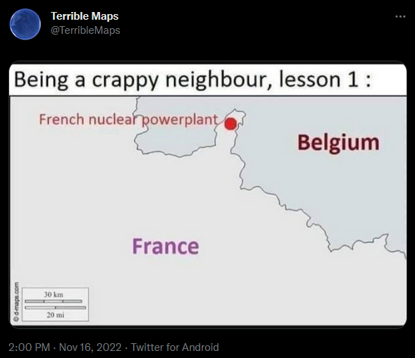
@Gurth I was going to make some
 funny comment about what "loch-ness" implies but Google Maps must have read my mind (
 ) when I asked it about it, and showed me something that is funnier than whatever quip I was going to make:
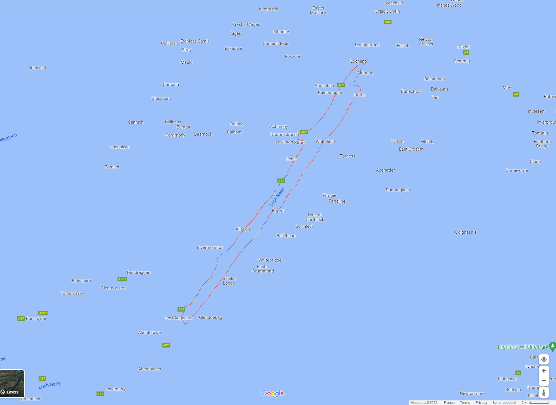
Filed under: maps of not Netherlands
-
@remi I didn't think sea levels had risen that much. It's raining, yes, but...
-
@remi Bodies of water, and especially the sea, are problematic beasts.
Also happens every now and then with some openstreetmap based maps that some areas are flooded by the sea, by a nearby lake, or that lakes are suddenly drained...
-
@remi said in Fun with maps:
what "loch-ness" implies
Joking aside, a loch is a lake... in Scotland (it's just a slightly different word for the same thing). Or an arm of the sea that is usually sufficiently enclosed to feel like a lake (and is sometimes called a sea loch). That second type of loch would be called a fjord if it was in Norway.
It's not an issue in standard English because that didn't have sea lochs or fjords to name and didn't really need the concept until much later.
-
@dkf Despite being
 and thus subject to the Mighty Académie, I'm very much a language descriptivist.
So when I'm not aiming for the pointless
, I'll say that a loch is whatever people call a loch, and that's it.
-
-
@remi said in Fun with maps:
So when I'm not aiming for the pointless
, I'll say that a loch is whatever people call a loch, and that's it.The thing there is, if you do that then you should also call, say, Lake Garda, “Lago di Garda” in English — because the people who live near it, call it that. That loch is the Scottish word for a stretch of fresh water or for a mostly enclosed one of salt water, sure. But people elsewhere have different names for such geographical features.
But I suppose it kind of fits with an apparently common tradition in English of referring to people from foreign countries using a mode of address of their native land, rather than the equivalent English one. For example, referring to a German man named Schmidt as “Herr Schmidt“ rather than “Mr. Schmidt”.
-
@Gurth I'm fairly sure this is the natural British passive-aggressive tendency at work - just enough effort to make you think we give a shit but not enough to actually give a shit.
-
@Gurth said in Fun with maps:
@Gribnit said in Fun with maps:
@Benjamin-Hall said in Fun with maps:
Is that a lake
No, it's a loch.
It seems the defining feature of a loch is that it’s a lake in Scotland — or so I gather from a conversation with a Scottish friend in which I called something that had Loch in its name, a “lake”. He would not accept my argument that the two words mean the same thing: the fact that it had Loch in the name made it a loch and not a lake … Yeah, sure, whatever.
Ah, yes, sparkling lakes.
-
@Gurth said in Fun with maps:
But I suppose it kind of fits with an apparently common tradition in English of referring to people from foreign countries using a mode of address of their native land, rather than the equivalent English one. For example, referring to a German man named Schmidt as “Herr Schmidt“ rather than “Mr. Schmidt”.
When we're taking the piss usually
-
-
@Gurth said in Fun with maps:
@remi said in Fun with maps:
So when I'm not aiming for the pointless
, I'll say that a loch is whatever people call a loch, and that's it.The thing there is, if you do that then you should also call, say, Lake Garda, “Lago di Garda” in English — because the people who live near it, call it that.
Note that I didn't specify which people I was referring to (see @HardwareGeek, even when not aiming for a pointless
I can still include pointless  ing!).
So I can call the same body of water Léman or de Genève (*), depending on who I'm talking with, and I'm not going to explode because "OMG the same thing has two different names but it's still the same thing!"
Yes, this can create confusion. But then again, even places with a single unanimously agreed-upon name can create confusion (e.g.

 ) so it's hardly something specific to translations. And we're talking language anyway, so unless you want to use the language that only our ex-resident
  expert (claimed to) use, you're going to have confusion. Deal with it or forever hold your peace.
(*) if I'm in a
 mood, I might use the first with those who naturally use the second and vice-versa, of course (the "things that remind you of WTDWTF posters" thread is, uh, wait...).
-
@remi said in Fun with maps:
So I can call the same body of water Léman or de Genève (*), depending on who I'm talking with, and I'm not going to explode because "OMG the same thing has two different names but it's still the same thing!"
There's a street here usually called New Kandy Road (of course it's way older than the highway so it's not a good way to get to Kandy) although some people call it Battaramulla Main Road and nobody calls it the official "Kotte-Bope Road". Of course it has Sinhala and Tamil names, too, but I'm not sure how many more variants they add each.
-
@LaoC said in Fun with maps:
There's a street here usually called New Kandy Road (of course it's way older than the highway so it's not a good way to get to Kandy) although some people call it Battaramulla Main Road and nobody calls it the official "Kotte-Bope Road".
In the city I grew up in there are a couple of customary names for some roads/crossings, that don't match the official names but that every one understands. For example one bridge is still referred to by the name of the previous bridge on the same place, that was demolished about 50 years ago.
In another place, everybody used a name that was related to a feature on the square (how some subterranean pedestrian crossings intersected) instead of the actual name of that square (I don't even have the slightest idea what the official name was). In a renovation project about 10-20 years ago, that feature was removed as the whole area was reorganised, but the city decided to make the nickname official. So now that's the official name of the place, but there is nothing to indicate why it's called this way, and I'm guessing that in a few years people will imagine some fancy-but-wrong back-story to explain it.
-
@loopback0 said in Fun with maps:
When we're taking the piss usually
Probably because of all that thee
-
@remi Given that you’re talking about France, that doesn’t surprise me at all, seeing there’s lots of places there where the demonym derives from a previous name that hasn’t been used for hundreds of years or even more.
-
-

